ASTROLOGY AS A STUDY OF PHYSICAL SPACE
©2000 by Angel Z. Thompson
Part I: The Origins of Longitude and LatitudeTraditional astrology is basically a study of movement through time. Using the signs and planets as significators of physical space is used in horary astrology (particularly to assist in finding lost items) and in location astrology to determine the effects of placement on personality and behavior.
Modern astrology, however, doesn't pay much attention to the physical nature of the planets, the psychological nature of the eight directions, longitude and latitude, universal time or other spatial phenomena. This is the first in a series of articles exploring the study of energy through space as a way to enrich our astrological understanding of the power of place as well as the effects of placement on the individual.
From the beginning of time, humankind used the five senses - sight, sound, touch, taste, and hearing - to figure out the mysteries of life and death, and the nature of Heaven and Earth. The ancients had some interesting ideas about the properties of the world. Egyptians saw the Earth as an egg guarded at night "By the Moon, a great white bird, like a goose brooding over her egg." To the Greeks, the Earth was a circular disk surrounded by the river Oceanus. Peruvians imagined a square Earth within a box-like world with a ridge-shaped roof. Hindus believed four elephants held the world on their shoulders while the Vedic poets believed the world was a tree, the tree of life, the tree of knowledge, and a sacred tree.
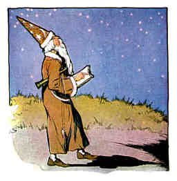
The Heavens were visible and presented a moving picture that was regular and predictable, making it possible to map and chart the night sky. Mapping and charting the Earth, however, was a different story because knowledge of the Earth was limited to what could be seen with the naked eye, how far one could walk, or how high one could climb. What was the Earth? Was it round or flat, part of something else or whole unto itself? How far did it go before disappearing into the unknown void? Today, this information is taken for granted; yet to discover these things must have required careful observation, great imagination, and infinite patience.
At first, elements of nature within the landscape were used to locate space and to tell time. Names were derived from locations so that a hillside place might warrant the name "Valley View," while a place near a river might be called "River Road." This was a very simple method for locating a specific place, but as convenient as this method was, it seemed unpredictable. Valleys disappeared with floods. Rivers changed courses. Everything on Earth was always changing, making it impossible to predict when natural events, such as the flooding of the river, or the coming of winter, might occur. Never moving, yet ever changing, it was impossible to predict what would happen on Earth tomorrow.
However, the position and movement of the Sun, the regular change of the shape of the Moon, and the patterns formed by the stars in the night sky remained fixed and constant. Ever moving but never changing, it was possible to predict what would happen in the Heavens tomorrow. Just as elements within the landscape provided markers for defining space, the Sun and the Moon, visible every where, and regular in their movement, became the markers of time, the hands on a great clock in the sky.
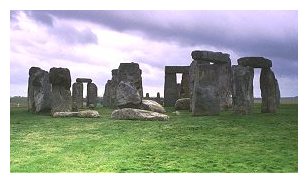
Using an apparently fixed object, like a mountain, as the fixed point of reference on Earth, the nightly passage of the Heavens could be watched, measured, and predicted. When there were no natural elements by which to mark the passing of the stars, sophisticated monuments were erected to keep track of celestial phenomenon. Stonehenge, Angor Wat, and other monoliths were constructed to mark the alignment of the Sun with specific stars, which indicated the beginning of a season or regularly occurring event, like the flooding of the river.
The Sun is a visible and predictable symbol of the passage of time. In the Northern Hemisphere, the Sun always rises in the East, travels through the South, and sets in the West. Its movement allows us to differentiate between one day and the next. Longer periods of time are also marked by the position of the Sun. In the Spring and Fall, the Sun rises in the East but during Winter and Summer, it can rise either in the NorthEast or SouthEast. This apparent motion made it easy to divide time into four distinct periods, or seasons, each with its own personality. Similarly, the periodicity of the Moon is regular and predictable and can be used to measure the passage of time. An event was "many Moons ago," or a festival might be scheduled for "the next full Moon" and everyone would know when that was.
This measuring and mapping of the Heavens was the beginning of measuring and mapping the Earth. However, as urbanization overwhelmed natural environments, new definitions of dividing space were needed. The invention of grid lines simplified this division, segmenting the Earth into areas that ran North and South as well as East and West. Grid lines defined space, making it possible to distinguished one place from another. Grid lines also defined time, measuring the time it took for the light of the Sun to move from one grid line to another.
As early as 350 BCE, the Greek philosopher, Aristotle, speculated that the Earth was round. He developed a grid system similar to that of longitude and latitude, which was easily drawn around a sphere. However, it was too difficult to
project a sphere on a flat surface, so in practice, his grid system was the same as if it were conceived on a flat Earth.
A hundred years later, after watching the round shadow of the Earth eclipse the full Moon, Eratosthenes validated Aristotle's idea. His observation of shadows helped him accurately measure the circumference of the Earth. About the same time, Hipparchus measured parallel lines equal distance from each other, starting at the equator, which he located by astronomical observation. He was also responsible for dividing the circle into 360 degrees, each degree corresponding to 70 miles, which was accurate to within ten miles of modern measurement.
Ptolemy, whom we know as an astronomer/astrologer, was also a 'Royal Geographer'. He was the first to distinguish the differences between geography and cartography (map making) and the first two chapters of his work, The Tetrabiblios, are devoted to geography. He named longitude and latitude "width and length" and arbitrarily started the custom of drawing maps with North at the top and East at the right. His maps calculated each degree to be the equivalent of about 50 miles. Unfortunately, his measurements were off by about 20 miles and this, along with other errors in measurement, tainted his work and so its value has been discounted.

After the death of Ptolemy, Christian dogma defined world geography, locating Heaven and Hell with great detail but ignoring most of the space in between. The Gnostics, Christian mystics of the first and second centuries, returned to their vision of Heaven and Earth as a World Egg, in the womb of the universe. Entwining the egg was a giant serpent, which warmed, guarded, hatched, and sometimes fed on the egg. The Earth was an element placed in the middle of the world. The Venerable Bede wrote in the 7th century that the Earth was "As the yolk in the middle of an egg. Around it is water, like the white surrounding the yolk; outside that is the air like the membrane of the egg and around all is the fire which closes it in as the shell does." So, after a very good start, in the West, geography returned to realm of the mystical and illuminating manuscripts took precedence over making detailed maps of the Earth.
While the Greeks were speculating, measuring, and charting a round Earth, the Chinese believed in a flat Earth and used rectangular grids. As early as 221 BCE, in the Ch'in Era, maps were commonplace. According to the Rites of Chou (1120-250 BCE) the Director General of unified China had to prepare maps of each feudal principality and register its population. Of course he had the Royal Geographer do this for him.
By 220 AD, the use of maps in China was extensive and by 129 AD Chang Heng had "cast a network of coordinates about Heaven and Earth". Phei Hsui (The Chinese Ptolemy) during the great Chin Dynasty, unified space in six directions, were drawn to scale, and included topographical details like mountains, rivers, and roads. These early maps were painted on fabric using the warp and weft as fixed coordinates. By the time of the T'ang Dynasty, about 801 AD, a grid map of the empire was completed, using celestial coordinates for points of reference, and drawn on a scale of one inch equal to 100 li (about l/3rd of a mile).
Genghis Khan and Kublai Khan brought these maps, and others, to Arabian mapmakers who developed a style their own style of map-making that was all grid, with no regard for natural shapes. From here, traders and explorers brought grid maps to Sicily and on to Western Europe.
It is clear that ancient people knew a great deal about stellar and geographical mechanics. Still, many centuries passed before we could tell time without the assistance of the Sun and Moon, or create a system to divide the Earth by what is now known as longitude and latitude. On the land and on the seas, it would be the astrologers, these stellar geographers, who would measure and map the world, as we know it today.
See Part II here.

ABOUT THE AUTHOR: Angel Thompson is a well known astrologer and feng shui practitioner who for the past twenty years has been building the bridge between Western astrology and Chinese philosophy. Her approach and her interpretation is humanistic yet practical. She combines the location techniques of astrology with the solutions and cures of compass school feng shui to create harmonious spaces for her clients. Angel is the acclaimed author of Feng Shui, How to Achieve the Most Harmonious Arrangement of Your Home and Office, published by St. Martin's Press in 1996, which is now in its sixth printing! To order a copy or to find out about Angel's services, visit her Web Page or send e-mail.
CREDITS: The background tile is by ABC Giant.